John Chapter 8:58 Jesus said to them, "Amen, amen, I say to you, before Abraham came to be, I AM." เชิงอรรถ Came to be, I AM: the Greek word used for "came to be" is the one used of all creation in the prologue, while the word used for "am" is the one reserved for the Logos.
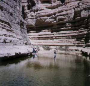
The ancient riverbed of Wadi Zin, in the Ein Avdat Canyon of the Negev, is fed by rainfall as well as mysterious subteranean springs.
Ein Avdat National Park Oasis in a stunning canyon Geography The Ein Avdat Canyon is part of Nahal Tzin - the largest wadi that begins in the Negev. The wadi bed of Nahal Tzin suddenly becomes active amidst and following torrential rainfall and drains into what once was the southern end of the Dead Sea (the sea slowly dries up on its southern end).
Source: THE BIBLICAL WORLD: AN ILLUSTRATED ATLAS National Geographic ISBN 9784 4262 01387 พระคัมภีร์พันธสัญญาใหม่คณะกรรมการคาทอลิกเพื่อพระคัมภีร์ NAB Bible
11 Then God said, "Let the earth bring forth vegetation: every kind of plant that bears seed and every kind of fruit tree on earth that bears fruit with its seed in it." And so it happened: 12 the earth brought forth every kind of plant that bears seed and every kind of fruit tree on earth that bears fruit with its seed in it. God saw how good it was.
ca 300,000 B.C.E Eary evedience of modern humans present near the sea of Galilee
ca 40,000 B.C.E Stone tools in use in ancient Israel
Source: THE BIBLICAL WORLD: AN ILLUSTRATED ATLAS National Geographic ISBN 9784 4262 01387 พระคัมภีร์พันธสัญญาใหม่คณะกรรมการคาทอลิกเพื่อพระคัมภีร์ NAB Bible
Genesis Chapter 3 23-24 23 The LORD God therefore banished him from the garden of Eden, to till the ground from which he had been taken. 24 5 When he expelled the man, he settled him east of the garden of Eden; and he stationed the cherubim and the fiery revolving sword, to guard the way to the tree of life.
เชิงอรรถ รายละเอียดนี้อาจคัดมาจากตำนานเทพของชาวบาบิโลน (ดู อพย 25:18 เชิงอรรถ I) The tree of life is a prominent symbol in Assyrain reliefs, such as this panel showing two portraits of King Ashurnasirpal worshippping a deity, possibly the god Shamash.
Assyria The Assyrian Tree of Life is represented by a series of nodes and criss-crossing lines. It is an important religious symbol among these peoples. It is often attended to by Eagle Headed Gods/Priests or the King himself.
Genesis Chapter 1-27 27 God created man in his image; in the divine image he created him; male and female he created them.
These scenes of Adam and Eve in Paradise as envisioned by Lucas Cranach the Elder(1472-1553) were painted around 1530
Genesis Chapter 2:8-9 8 3 Then the LORD God planted a garden in Eden, in the east, and he placed there the man whom he had formed. 9 Out of the ground the LORD God made various trees grow that were delightful to look at and good for food, with the tree of life in the middle of the garden and the tree of the knowledge of good and bad.
ต้นไม้แห่งชีวิต เป็ฯสัญญาลักษณ์ของชีวิตอมตะ (ดู3:22 เชิงอรรถ g)เกี่ยวกับต้นไม้แห่งความรู้ดีรู้ชั่ว ดู ข้อ 17 เชิงอรรถ j Genesis Chapter 2:10-14 10 4 A river rises in Eden to water the garden; beyond there it divides and becomes four branches. 11 The name of the first is the Pishon; it is the one that winds through the whole land of Havilah, where there is gold. 12 The gold of that land is excellent; bdellium and lapis lazuli are also there. 13 The name of the second river is the Gihon; it is the one that winds all through the land of Cush. 14 The name of the third river is the Tigris; it is the one that flows east of Asshur. The fourth river is the Euphrates.
Source: THE BIBLICAL WORLD: AN ILLUSTRATED ATLAS National Geographic ISBN 9784 4262 01387 พระคัมภีร์พันธสัญญาใหม่คณะกรรมการคาทอลิกเพื่อพระคัมภีร์ NAB Bible
Genesis 4:2-3 2 Next she bore his brother Abel. Abel became a keeper of flocks, and Cain a tiller of the soil. 3 In the course of time Cain brought an offering to the LORD from the fruit of the soil,
Jericho n : a village in Jordan near the north end of the Dead Sea; in the Old Testament it was the first place taken by the Israelites under Joshua as the entered the Promised Land [syn: {Jericho}]
Iron Age II fortification (Israelite Period) near the southern entrance to Jericho (Cf. 1Re 16,34)
The final section of Wadi el-Kelt where a stream comes down from the Mountain of Benjamin to water the fields of Jericho. On the right, you can see the Herodian aqueduct and the Arab village of Tulul Abu el-Alayiq
1. Qumran 2. Iron Age II Fortress 3. Herodian Palace (South) 4. Herodian and Asmonaean Palaces (North) 5. Tell es-Sultan and Elishas Fountain 6. Synagogue of Naaran 7. Synagogue of Jericho 8. Kh. al-Mafjar (Hisham Palace) 9. Jebel Qarantal (Temptation Mount) 10. Monastery of Choziba 11. Deir Hajla (St. Gerasimus) 12. Qasr al-Yahud (Prodromos) 13. Nebi Musa (Muslim shrine of Moses Tomb)
Israelite Jericho
Iron Age II fortification (Israelite Period) near the southern entrance to Jericho (Cf. 1Re 16,34)
Herodian Jericho
The final section of Wadi el-Kelt where a stream comes down from the Mountain of Benjamin to water the fields of Jericho. On the right, you can see the Herodian aqueduct and the Arab village of Tulul Abu el-Alayiq.
View of the Wadi el-Kelt road towards Tulul Abu el-Alayiq. The ancient Roman road has been in use until the beginning of the 19th century.
To the right: The Crusader structure identified by some of the pilgrims with the house of Bartimaeus, the blind man healed by Jesus (Lk 18:35-43).
The excavation area of Tulul Abu el-Alayiq seen from the west. This is Jericho of the Asmonaeans and of King Herod the Great (2nd cent. to 1st cent. BC). The dig of Herodian Jericho started in 1868 (C. Warren), continued in 1909 and 1911 (E. Sellin, C. Watzinger) upto the years 1950-1951 (J. Kelso, D. Baramki, J. Pritchard). Israeli archaeologists G. Foerster and E. Netzer started again the exploration with great eagerness during the periods 1973-1983 and 1986-1988. Excavation and restoration works are still in progress.
Ruins and foundations of the second Herodian palace. According to E. Netzer, it wasn't a military structure, rather a large laconicum or sweating hall.
Two large basins (m 13x18x3) constructed by Alexander Iannaeus (103-76 BC) to provide the city with a vital water reserve.
In the northern sector, there are many plastered vats and tanks to collect water. The Asmonaeans built a channel to bring here the water from the source of Ayn Duq (Nueima), and Herod the Great made an aqueduct from the source of Ayn el-Kelt.
Their occupation of the country is begun with the crossing of the Jordan and the conquest of Jericho (Jos 1-6), in both of which the Lord intervenes on their behalf. This is followed by a first foothold on the Palestinian mountain range, at Ai, Bethel, and Gibeon (Jos 7-9), and two sweeping campaigns against the city states in the south of the country (Jos 10) and in the north (Jos 11), with a summary in Jos 12. The broad claim to total sovereignty thus established is spelled out by a combined list of tribal boundaries and of the towns contained within each area or administrative district (Jos 13-19), including cities of asylum and cities for the Levites (Joshua 20:21). The book closes with a narrative about the tribes east of the Jordan (Jos 22), a warning speech by Joshua (Jos 23), and a renewal at Shechem (Jos 24) of the covenant with the Lord, already affirmed there near the beginning of the conquest (Joshua 8:30-35).
พิชิต คานาอัน Joshua 1:1-12:24) การแบ่งดินแดน (Joshua 13:1-21:45) Return of the Transjordan Tribes and Joshua's Farewell (Joshua 22:1-24:33)
Source: THE BIBLICAL WORLD: AN ILLUSTRATED ATLAS National Geographic ISBN 9784 4262 01387 พระคัมภีร์พันธสัญญาใหม่คณะกรรมการคาทอลิกเพื่อพระคัมภีร์ NAB Bible and KJV Bible //198.62.75.4/www1/ofm/sbf/escurs/TS/03b_TSen.html
10 7 The chief cities of his kingdom were Babylon, Erech, and Accad, all of them in the land of Shinar. 11 8 From that land he went forth to Asshur, where he built Nineveh, Rehoboth-Ir, and Calah, 12 9 as well as Resen, between Nineveh and Calah, the latter being the principal city. เชิงอรรถ [10] Shinar: ancient Sumer in southern Mesopotamia, mentioned also in Genesis 11:2; 14:1.
8 [11] Asshur: Assyria. Rehoboth-Ir: literally "wide-streets city," was probably not the name of another city, but an epithet of Nineveh; cf Jonah 3:3.
9 [12] Calah: Assyrian Kalhu, the capital of Assyria in the ninth century B.C.
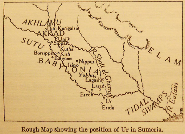
The partially reconstructed ziggurat of UR, built of mud bricks, rises over the ancient site of Ur in Iraq. It may have been dedicated to Nana , the moon god
Genesis Chapter 6:5 5 5 When the LORD saw how great was man's wickedness on earth, and how no desire that his heart conceived was ever anything but evil, เชิงอรรถ 5 [6:5-8:22] The story of the great flood here recorded is a composite narrative based on two separate sources interwoven into an intricate patchwork. To the Yahwist source, with some later editorial additions, are usually assigned Genesis 6:5-8; 7:1-5, 7-10, 12, 16b, 17b, 22-23; 8:2b-3a, 6-12, 13b, 20-22. The other sections come from the "Priestly document." The combination of the two sources produced certain duplications (e.g., Genesis 6:13-22 of the Yahwist source, beside Genesis 7:1-5 of the Priestly source); also certain inconsistencies, such as the number of the various animals taken into the ark (Genesis 6:19-20; 7:14-15 of the Priestly source, beside Genesis 7:2-3 of the Yahwist source), and the timetable of the flood (Genesis 8:3-5, 13-14 of the Priestly source, beside Genesis 7:4, 10, 12, 17b; 8:6, 10, 12 of the Yahwist source). Both biblical sources go back ultimately to an ancient Mesopotamian story of a great flood, preserved in the eleventh tablet of the Gilgamesh Epic. The latter account, in some respects remarkably similar to the biblical account, is in others very different from it.
ภาษาไทย ยาวเจงเจงขอสแกนค่ะ
Genesis Chapter 6 :19 19 Of all other living creatures you shall bring two into the ark, one male and one female, that you may keep them alive with you.
Genesis Chapter 6: 14-19 14 6 Make yourself an ark of gopherwood, put various compartments in it, and cover it inside and out with pitch. 15 7 This is how you shall build it: the length of the ark shall be three hundred cubits, its width fifty cubits, and its height thirty cubits. 16 8 Make an opening for daylight in the ark, and finish the ark a cubit above it. Put an entrance in the side of the ark, which you shall make with bottom, second and third decks. 17 I, on my part, am about to bring the flood (waters) on the earth, to destroy everywhere all creatures in which there is the breath of life; everything on earth shall perish. 18 But with you I will establish my covenant; you and your sons, your wife and your sons' wives, shall go into the ark. 19 Of all other living creatures you shall bring two into the ark, one male and one female, that you may keep them alive with you. เชิงอรรถ 6 [14] Gopherwood: an unidentified wood not mentioned elsewhere; gopher is merely the Hebrew word for it.
7 [15] The dimensions of Noah's ark were approximately 440 x 73 x 44 feet, a foot and a half to the cubit. The ark of the Babylonian flood story was an exact cube, 120 cubits in length, width and height.
8 [16] Opening for daylight: a conjectural rendering of the Hebrew word sohar, occurring only here. The reference is probably to an open space on all sides near the top of the ark to admit light and air. The ark also had a window or hatch, which could be opened and closed (Genesis 8:6).
ภาษาไทยขอสแกนค่ะ ยาว
What these and other stories suggest is that the oral tradition of Genesis was very familiar with and possibly informed by the myths of ancient Mesopotaimia.
Source: THE BIBLICAL WORLD: AN ILLUSTRATED ATLAS National Geographic ISBN 9784 4262 01387 พระคัมภีร์พันธสัญญาใหม่คณะกรรมการคาทอลิกเพื่อพระคัมภีร์ NAB Bible and KJV Bible
A ziggurat to build on a raised area is a temple tower of the ancient Mesopotamian valley and Iran, having the form of a terraced pyramid of successively receding stories. Ziggurats were a form of temple common to the Sumerians, Babylonians and Assyrians of ancient Mesopotamia.The earliest examples of the ziggurat date from the end of the third millennium BCE and the latest date from the 6th century BCE.
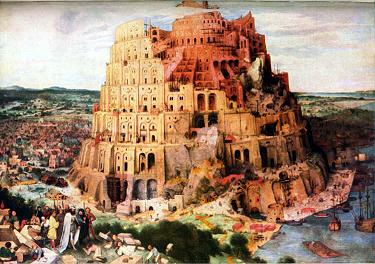
Genesis Chapter 11 :3-4
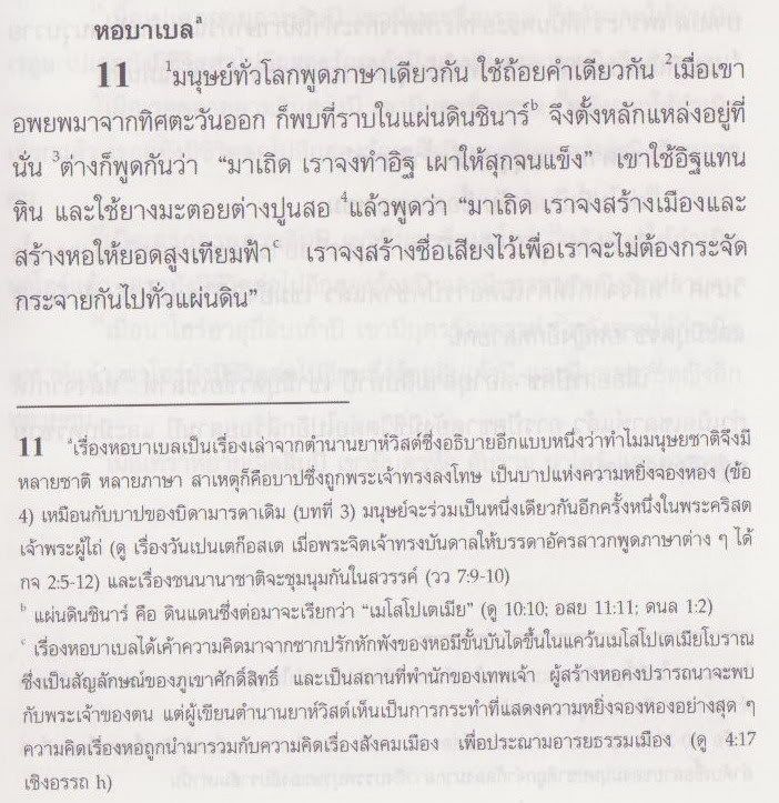
3 They said to one another, "Come, let us mold bricks and harden them with fire." They used bricks for stone, and bitumen for mortar. 4 3 Then they said, "Come, let us build ourselves a city and a tower with its top in the sky, and so make a name for ourselves; otherwise we shall be scattered all over the earth." เชิงอรรถ [4] Tower with its top in the sky: a direct reference to the chief ziggurat of Babylon, the E-sag-ila, signifying "the house that raises high its head." Babylonian ziggurats were the earliest skyscrapers.
King Naram-sin of Akad, wearing a hormed tiara, towers over his vanquished enemies. this pink sand stone stela dates to around 2250 B.C.E. and was found in Sua , Iran Source: THE BIBLICAL WORLD: AN ILLUSTRATED ATLAS National Geographic ISBN 9784 4262 01387 พระคัมภีร์พันธสัญญาใหม่คณะกรรมการคาทอลิกเพื่อพระคัมภีร์ NAB Bible and KJV Bible
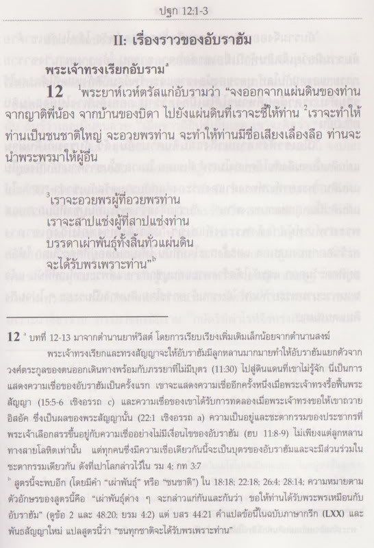
พระเป็นเจ้าผู้ซึ่ให้พันธสัญญาไว้กับอับราฮัม คือประชากรที่พระเป็นเจ้าเลือกสรร พระเป็ฯเจ้าให้พันธสัญญาว่าจะให้อับราฮัม "great nation"ชนชาติที่ยิ่งใหญ่ และให้"to the land that I will show you- The promised Land." ให้ดินแดนที่พระองค์ทรงสัญญา
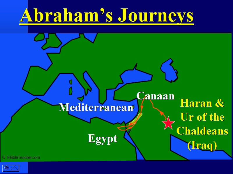
Family History Genesis Chapter 12:1-2 1 The LORD said to Abram: "Go forth from the land of your kinsfolk and from your father's house to a land that I will show you. 2 "I will make of you a great nation, and I will bless you; I will make your name great, so that you will be a blessing. ภาษาไทยยาวเจงเจงขอสแกนค่ะ
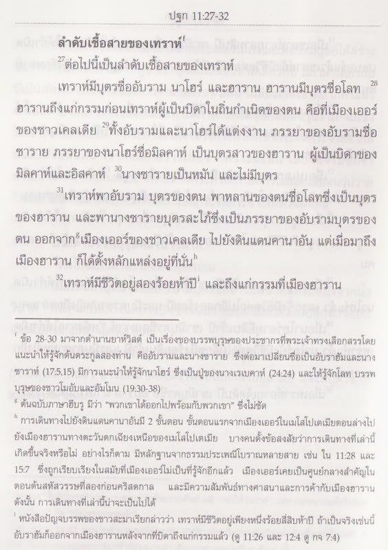
การเริ่มต้นของปฐมกาลสโคปเรื่องความเป็นอยู่ของมนุษย์แรกเริ่มบนพื้นดิน และเริ่มต้นของต้นตะกูล 12 เผ่า ของอิสราเอล ปฐมกาลได้อธิบาย อับราฮัมเป็นลูกของ Terah เชื้อสายลูกหลานของโนอาร์ จากปฐมกาลเรื่องน้ำท่วมโลก Genesis Chapter 11:28 28 8 Haran died before his father Terah, in his native land, in Ur of the Chaldeans. เชิงอรรถ [28] Ur of the Chaldeans: Ur was an extremely ancient city of the Sumerians (later, of the Babylonians) in southern Mesopotamia. The Greek text has "the land of the Chaldeans." In either case, the term Chaldeans is an anachronism, because the Chaldeans were not known to history until approximately a thousand years after Abraham's time. ภาษาไทยยาวเจงเจง ขอสแกนค่ะ The Ugaritic texts การพบทางโบราณคดี พระราชวัง Mari เมืองเก่า Ugarit ตอนนี้อยู่ที่ ซีเรีย ใกล้ๆๆทางทิศตะวันออก จากยูเฟรติส Tell Hariri 30 ไมล์ตอนเหนือของชายแดน ซีเรียและอิรัก Mari แลกเปลี่ยนค้าขายกะอียิป และบาบิโลน นักโบราณคดีชาวฝรั่งเศส Claude Schaeffer เป็นที่ประหลาดใจ จากการค้นพบแผ่นจารึก อาณาจักร อักคาเดียน สมัย King Sargon และพบ 30 ตัวอักษร UGaritic คล้ายๆๆอักษร เซเมติกตอนเหนือ บางตัวเป็ฯอักษรฮิบรู ตัวอย่างแผ่นจารึก Tablet of King Zimri-Lim of Mari, ca. 1780 BC, Louvre Museum
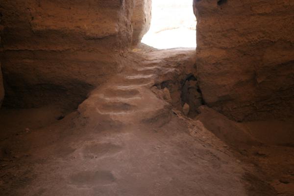
แผ่นจารึกของ The Mari ตอบคำถามได้ การใช้ชีวิตของอับบรฮัม การเกษตร"อิสอัคหว่านพืชในแผ่นดินนั้น และในปีนั้น เขาเก็บเก็บเกี่ยวผลผลิตได้ถึงร้อยเท่า เพราะพระยาห์เวย์ทรงอวยพรเขา" ปฐมกาล 26:12 และนักวิจัยบางกลุ่มกะเชื่อว่า Terah คือชนเผ่า Amorites(or Amurru in Akkadian) 2100 B.C.E. ที่ผ่านมาอาศัยอยู่ทางตอนใต้ของเมโสโปเตเมีย บางตัวอักษรของMar บรรจุเรื่อง Amorite อ้างถึงเกี่ยวกะ ความเหมือนของชื่อในปฐมกาล "Terah, Nahor Serug and Harn Source: //www.traveladventures.org /continents/asia/images/mari09.jpg> Stair ascend inside the royal palace of Mari, Around the year 1760 B.C.E. Babylonian King Hammuarabi destoroyed the palace, located near todays TELL HARIRI in Syria
Intendant Ebih-Il, found in the temple of Ishtar at Mari, Archaic Dynasties (ca. 2400 BC), Louvre Museum ปฐมกาลบอกไว้ว่า Terah พาอับราฮัม บุตรของตน พาหลานของตนชื่อ โลทซึ่งเป็ฯบุตรของฮาราน และพาซารายบุตรสะใภ้ซึ่งเป็ฯภารยาของอับราฮัมบุตรของตน ออกจาเมืองเออร์ของชาวคลอเดีย ไปยังดินแดนคานาอัน
แต่มาถึงเมืองฮาราน ก็ได้ตั้งหลักแหล่งที่นั้น ปฐมกาล 11:32 ภายใต้ความแน่ใจว่าตอนใต้ของ UR คือทะลทางตะวันออกชายฝั่งของ Elamites และทางตะวันตกไม่มีอะไรมีแต่ทะเลทราย กองคาราวานไปทางตอนเหนือของ ยูเฟรตริส ข้าม Feritle Haran ปัจจุบันคือตุรกี และใจกลางการค้าขายของชาวสุเมเรียน ทางตอนนี้ และเป็นอาณจักรของ King Sargon Source: THE BIBLICAL WORLD: AN ILLUSTRATED ATLAS National Geographic ISBN 9784 4262 01387 พระคัมภีร์พันธสัญญาใหม่คณะกรรมการคาทอลิกเพื่อพระคัมภีร์ NAB Bible and KJV Bible //terraeantiqvae.blogia.com/2006/100201-descubren-templo-neolitico-en-el-norte-de-siria.php //www.answers.com/topic/mari-syria
ABRAHAMI PATRIARCHAE PEREGRINATIO ET VITA Abraham Ortelius, Theatrum Orbis Terrarum, Antwerp, 1586 ABRAHAM EGREDERE DE TERRA TUA ET DE COGNATIONE TUA ET VENI IN TERRAM QUAM MONSTRAVERO TIBI. "Abraham, go out from thy country, and from thy kindred, and go into the land which I will show thee." [From Genesis 12:1] ET DABO TIBI ET SEMINI TU POST TE TERRAM PEREGRINATIONIS TUAE OMNEM TERRAM CHANAAN IN POSSESSIONEM AETERNAM. "And I will give to thee, and to thy seed after thee, the land of thy sojournment, all the land of Chanaan for an eternal possession." [From Genesis 17:8]
Twenty-two vignettes of the life of Abraham surround the map of the land of Chanaan, centered on Jerusalem, with an inset for the journey of Abraham from Ur of Chaldea to Salem.
Inset: ITER ABRAHAMI PATRIARCHฦ. The journey of Abraham the Patriarch from Ur of Chaldea to Salem.
Source: THE BIBLICAL WORLD: AN ILLUSTRATED ATLAS National Geographic ISBN 9784 4262 01387 พระคัมภีร์พันธสัญญาใหม่คณะกรรมการคาทอลิกเพื่อพระคัมภีร์ NAB Bible and KJV Bible
Genesis Chapter 12:6-7 6 Abram passed through the land as far as the sacred place at Shechem, by the terebinth of Moreh. (The Canaanites were then in the land.) 7 The LORD appeared to Abram and said, "To your descendants I will give this land." So Abram built an altar there to the LORD who had appeared to him.
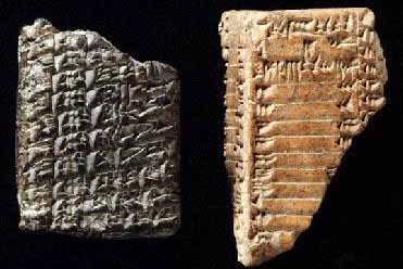
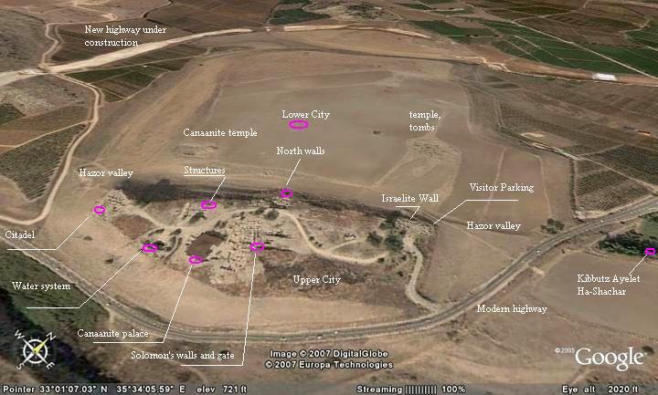
(1938-1908 B.C.E.) King อียิป Amenemhet คานาอันได้ตกเป็นเมืองขึ้นของอียิป อับราฮัมได้ปะทะต่อสู้ กะเมือง Hazor ภูมิประเทศ ประมาณ 200 เอเคอร์ ในกลาง ศตวรรษที่ 19 ก่อนคริสกาล เมืองนี้ มี20,000 คน ได้เก็บสำรองน้ำ จากน้ำพุธรรมชาติ ใกล้ๆๆ Nahal Harzor Source://www.crystalinks.com/tabletshazor.jpg The Tel Hazor Tablets
Hazor is the largest biblical-era site in Israel, covering some 200 acres. These two clay tablets written in cuneiform were found in the vicinity of the Canaanite palace.
โยซูวา 11:10 10 ขณะนั้น โยชูวากลับมายึดเมือง ฮาโซร์และประหารเจ้าเมืองเสียด้วยดาบ เพราะว่าแต่ก่อนนี้ฮาโซร์เป็นหัวหน้าแห่งแผ่นดินเหล่านั้นทั้งหมด Joshua Chapter 11:10 10 At that time Joshua, turning back, captured Hazor and slew its king with the sword; for Hazor formerly was the chief of all those kingdoms. ไม่แปลกใจที่ เมืองฮาโซร์ปรากฎใน ศตวรรษที่ สิบเจ็ดก่อนคริสกาล จากหลักฐาน หินจารึก จาก Mari และอักษร อียิป ในศตวรรษที่ สิบเก่า ก่อนคริสกาล ในไบเบิ้ล อับราฮัมไม่ได้อยู่ในเมือง ฮาโซร์ ผู้นำคือ Shechem หลักฐานขุดค้น ใน Khirbat balatah ทางตอนใต้ ปัจจุบันคือเมือง Nablus อยู่ระหว่างเทือกเขา Gerizim และเทือกเขา Ebal อับราฮัมเดินทางกะพ่อเขา ทางตอนใต Bethel และ hebron ทางเทืองเขา Judean และอับราฮัมเลือก an altar to the glory of EI
Source: THE BIBLICAL WORLD: AN ILLUSTRATED ATLAS National Geographic ISBN 9784 4262 01387 พระคัมภีร์พันธสัญญาใหม่คณะกรรมการคาทอลิกเพื่อพระคัมภีร์ NAB Bible and KJV Bible
Source: THE BIBLICAL WORLD: AN ILLUSTRATED ATLAS National Geographic ISBN 9784 4262 01387 พระคัมภีร์พันธสัญญาใหม่คณะกรรมการคาทอลิกเพื่อพระคัมภีร์ NAB Bible and KJV Bible
THE FINAL TEST Source://www.israel-on-blog.com/wp-content/uploads/2007/10/dead-sea-7.jpg En =gedi are ecrusted with salt from the Dead Sea, which has a 22-23 Percent saline content.
Genesis Chapter 19:24-26
24 at the same time the LORD rained down sulphurous fire upon Sodom and Gomorrah (from the LORD out of heaven). 25 6 He overthrew those cities and the whole Plain, together with the inhabitants of the cities and the produce of the soil. 26 But Lot's wife looked back, and she was turned into a pillar of salt. เชิงอรรถ
6 [25] Overthrew: The consistent use of this term, literally "turned upside down," to describe the destruction of the Cities of the Plain seems to imply that their upheaval (Genesis 19:29) was caused primarily by an earthquake; this would naturally be accompanied by a disastrous fire, especially in a region containing bitumen (Genesis 14:10) and its accompanying gases. ปฐมกาล 19:24-26 24 พระยาห์เวห์ทรงบันดาลให้กำมะถันและไฟตกจากฟ้า เผาเมืองโสโดมและโกโมราห์ 25 พระองค์ทรงทำลายสองเมืองนี้ ลุ่มแม่น้ำทั้งหมดพร้อมชาวเมือง และพืชต่างๆๆที่ นั้น 26 ส่วนภารยาของโลทเหลียวหลังกลับไปดูจึงกลายเป็นเสาเกลือ เชิงอรรถ ในต้นฉบับภาษา ฮิบรูยังย้ำอีกว่า "จากพระยาห์เวห์" รายละอียดของเรื่องนี้ทำให้เราคิดภว่าภัยพิบัติที่เกิดขึ้นมาจากแผ่นดินไหวร่วมกับแกสระเบิด ทางตอนใต้ของทะเลตาย นักธรณีวิทยาคำนวณว่าส่วนใต้ของทะเลตายได้จมลงก่อนนี้ไม่กี่พันปี และบริเวณนี้ทั้งหมดยังเกิดแผ่นดินไหวบ่อยๆๆ นอกจากเมืองโสโดม และโกโมราห์แล้ว (อสย 1:910 อมส 4:11) ยังมีเมืองอื่นถูกทำลายอีกด้วยคือ เมือง อัดมาห์และเศโบยิม(ปฐก 14: ฉธบ 29:22 ฮชย 11:8)
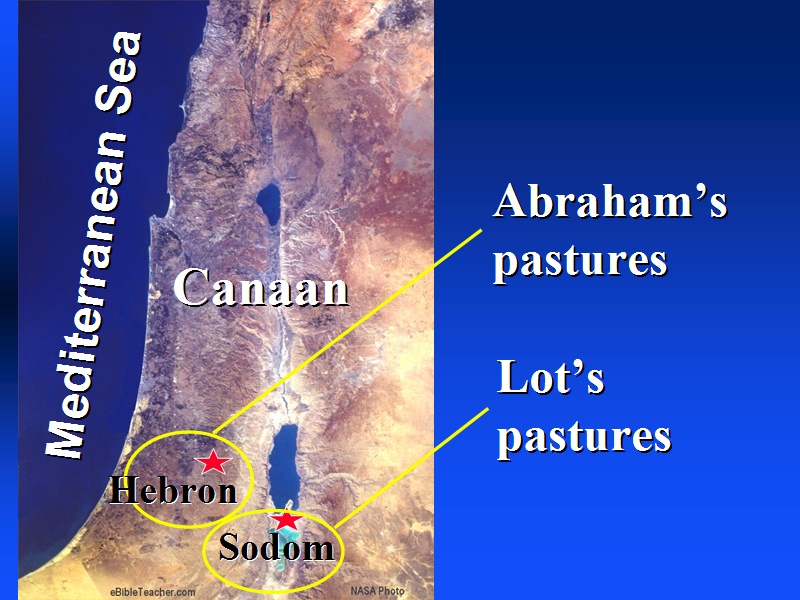
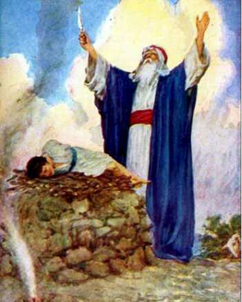
ในปี 1969 จากหลักฐานทางโบราณคดีของ Beersheba เป็นเมืองสำคัญรองจาก Israel's Negev ที่ Beersheba อับราฮัมได้ตั้งเต็นท์ขึ้นที่เมืองนี้ด้วย ในบทปฐมกาล 22:2 2 พระเจ้าตรัสว่า "จงพาอิสอัคบุตรของท่าน บุตคนเดียวที่ท่านรักไปยังดินแดนโมริยาห์" เชิงอรรถ 2 พศด 3:1 พูดถึงดินแดนโมริยาห์ว่าเป็นที่เดียวกัยเนินเขาซึงต่อมาจะเป็ฯที่ตั้งของพระวิหารแห่งกรุงเยรูซาเล็ม ธรรมประเพณีได้ยอมรับความคิดนี้ แต่จริงแล้ว พระคัมภีร์กล่าวถึง "ดินแดนโมริยาห์" ซึ่งเราไม่รู้ว่าอยู่ที่ใหน เพราะไม่มีกล่าวถึงในที่อื่นใดอีก Genesis Chapter 22:2 2 2 Then God said: "Take your son Isaac, your only one, whom you love, and go to the land of Moriah. There you shall offer him up as a holocaust on a height that I will point out to you."
เชิงอรรถ 2 [2] Only one: uniquely precious, especially loved; therefore the same term is rendered in Genesis 22:12, 17 as "beloved."
Source: THE BIBLICAL WORLD: AN ILLUSTRATED ATLAS National Geographic ISBN 9784 4262 01387 พระคัมภีร์พันธสัญญาใหม่คณะกรรมการคาทอลิกเพื่อพระคัมภีร์ NAB Bible and KJV Bible
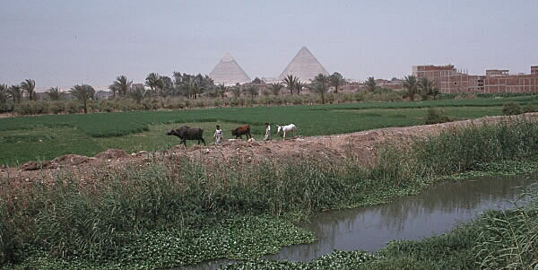
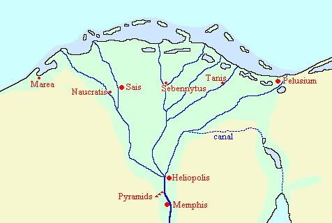
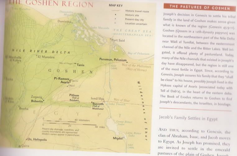
เรื่องของโยแซฟ สรุปในปฐมกาล ตามตัวอักษร หลัก คือ ระหว่างประวัตศาสตร์ ที่มาจากยุคแรกๆๆ อับราฮัม บ่อเกิดรากฐาน อิสราเอล Watered by several tributaries, the Nile Delta is Egypt's most fertile region. According to Genesis, Pharaoh settled the tribe of Jacop here.
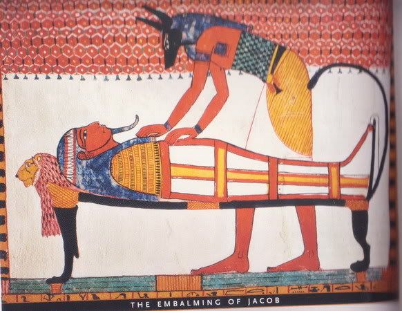
Jacob's son Joseph (pbut) is known to have passed through the land of Jordan only once as an adult, (Genesis 50:10,11). He and other members of the family brought the body of their father Jacob for mourning at a place called "the threshing floor of Atad, which is beyond the Jordan" (i.e., east of the Jordan River Valley), after which they took it for its final burial in Canaan.
Source: THE BIBLICAL WORLD: AN ILLUSTRATED ATLAS National Geographic ISBN 9784 4262 01387 พระคัมภีร์พันธสัญญาใหม่คณะกรรมการคาทอลิกเพื่อพระคัมภีร์ NAB Bible and KJV Bible
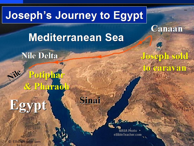
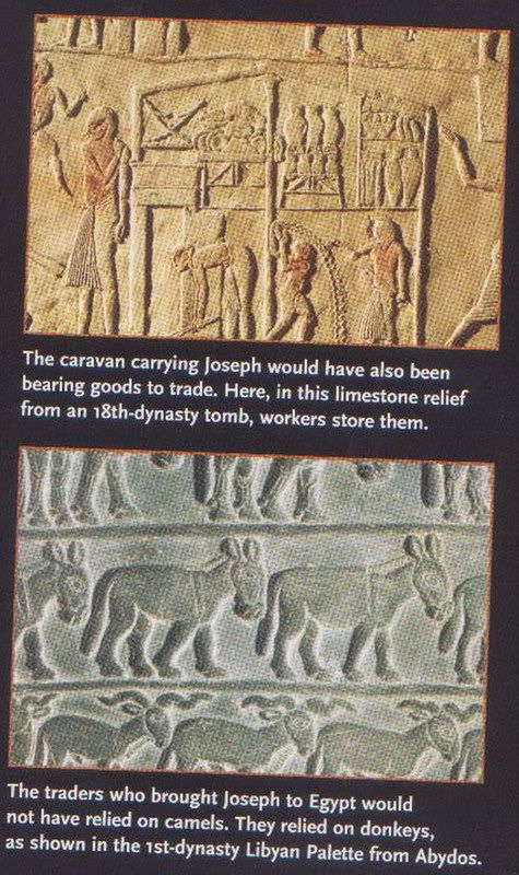
Joseph's Journey ปฐมกาล 37:25 25 แล้วพี่ชายทุกคนนั่งกินอาหาร ทันใดนั้น เขาเงยหน้าขึ้น เห็นกองคาราวานของชาวอิชมาเอลกำลังเดินทางมาจากแคว้นกิเลอาดจะไปประเทศอียิปต์ มีอูฐบรรทุกยางสนเครื่องเทศและไม้หอมด้วย มีการค้นพบหลักฐานเส้นทางคาราวาน ประมาณ 1200 ก่อนคริสกาล และมาจนถึงราชวงค์ดาวิด การค้าขาย ในศตวรรษที่ 6-5 ก่อนคริสกาล ในหนังสือ Pentateuch ที่เรียกปัจจบรรพ ความเจริญของอียิปต์เริ่มต้นในca 2575-2450 B.C.E. ฟาโรว์ Snefru ได้ทาส 7000 คน และวัวควายประมาณ 200,000 จากชัยชนะ Nubians ดังนั้น การค้าขายของอาหรับ ไปจนถึงอียิปต์ ดังที่ปฐมกาล อธิบาย จาก Gilead เป็นไปได้ที่ ใกล้ๆๆกะที่อยู่ของJacob เครื่องเทศ ข้าวโพด การค้าขาย เส้นทางกษัตริย์ King highgway จาก Mari ไป Qatna และไป Damascus ข้ามไป Transjordan ก่อนข้ามไปดินแดน คานาอัน ตรงไปยังหมู่บ้าน Valley of Jezereel. ปัจจับัน คือ Gulf of Aqaba หรือ Elat เป็นที่ ขนถ่ายสินค้าทางเรือ ทางตอนใต้ของอียิปต์ The photo of Josephs family journey into Egypt shows the fertile Nile delta as the Nile empties into the Mediterranean Sea. During the famine, this became the home of the Israelites.
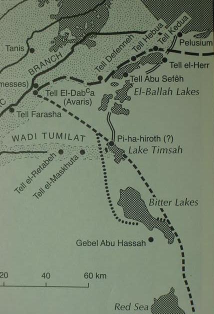
จากทัศนะ อธิบายใน ปฐมกาล เป็นไปได้ว่า โยแซฟ เกิดขึ้นใน Nothern Kindom at the court of the Hykos Pharaoh ไม่ว่าจะ ราชสำนัก Egyptian king ใน Thebes The Hyksos ตั้งขึ้นราชวงค์ใน Avaris นักโบราณคดีใน ออสเตรเลีย Manfred Bietak เชื่อว่า Avaris เมืองขนาดใหญ่ใน Hyksos กระบวนการขุดค้นหาวัตถุโบราณ (ในสถานที่ทางประวัติศาสตร์), ที่ Tell el Dab'a ขุดไป 200 ฟุต ซากอิฐ พระราชวัง ศตวรรษ ที่ 16 ก่อนคริสกาล เชื่อกันว่าคือ Hyksos Avaris เล็กกว่าเมืองคับคั่ง Memphis หรือ Thebes ความหรูหรา ความประทับใจจากหนุ่มน้อยคานาอัน โยแซฟตัดสินใจ ทำให้ดีที่สุด ใน สถานการณ์ที่ลำบาก ปฐมกาล 39:4 จึงพอใจโยแซฟ ให้เขาเป็นผู้รับใช้ส่วนตัวแต่งตั้งให้เขาดูแลบ้าน ปฐมกาล 39:6 โปทิฟาร์จึงมอบหมายทุกสิ่งที่ เขามีให้โยแซฟดูแล ไม่สนใจและไม่ห่วงใยสิ่งใดเลย นอกจากอาหารที่เขากินเท่านั้น ปฐมกาล 39:15 เมื่อเขาได้ยินฉันตะโกนก็เลยทิ้งเสื้อไว้กับฉัน วิ่งออกไปข้างนอก และโปติฟาร์ส่งโยแซฟไปเรือนจำ กะมีนิทานเรื่องเล่าของชาวอียิปต์ "The Tale of Two Brothers"
Source: THE BIBLICAL WORLD: AN ILLUSTRATED ATLAS National Geographic ISBN 9784 4262 01387 พระคัมภีร์พันธสัญญาใหม่คณะกรรมการคาทอลิกเพื่อพระคัมภีร์ NAB Bible and KJV Bible
The Mystery of the Hksos Avaris, The Capital of the Hyksos, Recent Excavations at Tell el-Dab'a. London. British Museum Press. 1996. ISBN 0-7141-0968-1
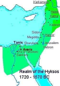
ภาษากรีก ชื่อ "Hyksos " กะคือเหรียญจาก Manetho จากหลักฐาน ราชวงค์ ที่ 15 his fifteenth Dynasty of Asiatic rulers of northern Egypt. เป็นคำมาจากภาษาอียิปต์ แปลว่า ผู้ปกครองชาวต่างประเทศอะ "ruler(s) of foreign countries" (Meyers 1997, 3:133) which Manetho mistranslated "Shepherd Kings".
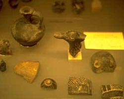
Tell el-Yahudiyeh ware
The Hyksos were of West Semitic background probably from southern Palestine who migrated down into northern Egypt during the 12th and 13th dynasties. At first they lived peacefully with the Egyptians until the deterioration of Egypt's power when in 1648 BC they captured the Egyptian capital at Memphis.
The Hyksos made Avaris their capital which is modern Tell ed-Dab'a, which was later known as Piramesse (Exodus 1:11). "Avaris" is the Greek term for the Egyptian Hwt-w'rt meaning "mansion of the desert plateau" (Meyers 1997 3:134). Other important Hyksos cities were Tell el-Yahudiyeh (meaning "mound of the Jews") known for its distinctive black and white ware, and Tell el-Maskhuta (probably Succoth in Exodus 12:37 NIV note, 13:20).
Source:Institute for Biblical & Scientific Studies
THE BIBLICAL WORLD: AN ILLUSTRATED ATLAS National Geographic ISBN 9784 4262 01387 พระคัมภีร์พันธสัญญาใหม่คณะกรรมการคาทอลิกเพื่อพระคัมภีร์ NAB Bible and KJV Bible
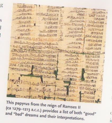
"Teachings of Merikare, written by King Kheti for his son the king warns that dreams การบอกให้รู้ล่วงหน้า นั้นคือความฝัน ตามแบบฉบับ ความหมายถูกต้องแม่นยำซึ่งตรงกันข้ามกะจุดประสงค์ สิ่งที่ปรากฏสิ่งที่ตั้งใจจะพูดหรือบอกด้วยเหมือนกัน
ปฐมกาล 40:8 "Do not interpretations belong to God" 8 ทั้งสองตอบว่า "เราต่างฝันไป แต่ไม่มีใครทำนายฝันเราได้" เชิงอรรถ ชาวอียิปต์เชื่อว่า ความฝันบอกให้เรารู้เหตุการณ์ในอนาคต
THE BIBLICAL WORLD: AN ILLUSTRATED ATLAS National Geographic ISBN 9784 4262 01387 พระคัมภีร์พันธสัญญาใหม่คณะกรรมการคาทอลิกเพื่อพระคัมภีร์ NAB Bible and KJV Bible
The Clan Moves to Egypt เผ่าพันธุ์ย้ายออกจากอียิปต์
Source://www.metmuseum.org/explore/newegypt/images/large/stela.jpg This stone slab shows Mentuwoser, a high offical at the court of Senusret I (ca 1918-1875 B.C.E.) presiding over his funeral banquet.
The Pastures of Goshen Jacob's Family Settles in Egypt ปฐมกาล 46:29 46:29 โยเซฟก็จัดรถม้าของตนขึ้นไปยังเมืองโกเชนรับอิสราเอลบิดาของตน พอเห็นบิดาท่านก็กอดคอบิดาไว้ร้องไห้เป็นเวลานาน
Source:Institute for Biblical & Scientific Studies
THE BIBLICAL WORLD: AN ILLUSTRATED ATLAS National Geographic ISBN 9784 4262 01387 พระคัมภีร์พันธสัญญาใหม่คณะกรรมการคาทอลิกเพื่อพระคัมภีร์ NAB Bible and KJV Bible
Biblical ArcheologyBible and Archaeology, History, Discoveries Customs, Manners
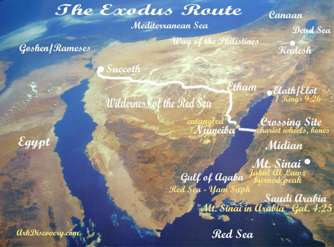
Mount Sinai was the destination of Moses and the Children of Israel after the Lord miraculously delivered them from the bondage of Egypt (Ex. 18:5). It was from this mountain that the Lord also gave the Ten Commandments to Moses and the people of Israel (Ex. 19:1-3, 11,18; 20:1-17). Here, too, the prophet Elijah found himself after his escape from wicked Queen Jezebel (I Kings 19).
Source://www.biblicalarcheology.net/wp-content/uploads/2007/03/saudi1-small.jpg Map of the route of the Exodus according to Har-El
Whos Who Among the Treasure Hunters: The idea of Mt. Sinai being in Midian (Saudi Arabia) is not new. Charles Beke suggested Mount Baggir, to the NE of the Gulf of Akaba, as the true location of Mt. Sinai in his book Sinai in Arabia and of Midian in 1878. Alois Musil (1926: 263,264, 269, 296-298) and H. Philby (1957: 222-224) identify Mt. Sinai / Horeb with Jebel al-Manifa, near Wadi al-Hrob, 20 kilometers north of Ajnuna (1926: 269, 297). A French scholar, Jean Koenig (1971), has added the volcanic peak of Halal bedr to the list.
St. Catherines Monastery at the base of Jebel Musa, the traditional location of Mt. Sinai. It was founded as both a monastic center and a pilrimage site. The basilical Church of Justinian inside the coimpound was built between 548 and 565. In addition to the functional buildings, a burning bush and well of Moses are located within the walls of the monastery.
Source:Institute for Biblical & Scientific Studies
Biblical ArcheologyBible and Archaeology, History, Discoveries Customs, Manners
THE BIBLICAL WORLD: AN ILLUSTRATED ATLAS National Geographic ISBN 9784 4262 01387 พระคัมภีร์พันธสัญญาใหม่คณะกรรมการคาทอลิกเพื่อพระคัมภีร์ NAB Bible and KJV Bible
Source:Institute for Biblical & Scientific Studies
Biblical ArcheologyBible and Archaeology, History, Discoveries Customs, Manners
THE BIBLICAL WORLD: AN ILLUSTRATED ATLAS National Geographic ISBN 9784 4262 01387 พระคัมภีร์พันธสัญญาใหม่คณะกรรมการคาทอลิกเพื่อพระคัมภีร์ NAB Bible and KJV Bible
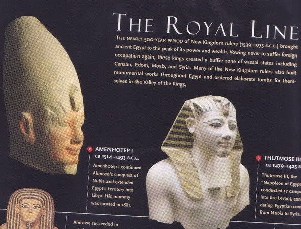
ข้อความที่บันทึกไว้ ในหินจารึก Karnak ประมาณ 1460 B.C.E. Thou has made captive the heads of the Asiatics of (Canaan) จากนั้นจุดแห่งชัยชนะ ฟาโรว์ทุกๆๆองค์ ใน 19-20th dynasties กะเป็นผู้นำ และศตรูทางฝั่งตะวันออกไปถึง คานาอันและซีเรีย และผู้นำรัฐกะจ่ายค่าส่วย สินไหม
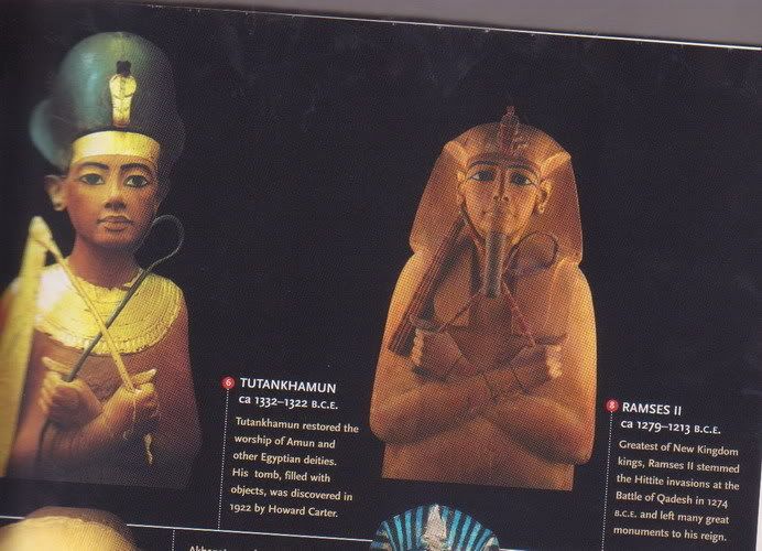
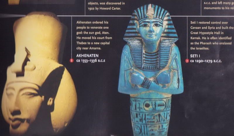
" Please my king " wrote the Egyptian governor of Jerusalem Abdiheba, send archers against the men who commiting these crimes. แต่ Akhenaten กะสนใจเล็กน้อย สำหรับชนต่างชาติของชาวอียิปต์ เมื่อพระองค์สิ้นพระชมน์ ในปี 1336 B.C.E. สภาขุนนาง กะละทิ้ง Amarna และ กลับไปที่ Memphis กะเป็นการสิ้นสุดของ Akhenaten ลูกของพระองค์ Tutankhaten กะเป็นฟาโรว์ ลูกของท่านเปลี่ยนชื่อเป็ฯ Tutankhamun (the liveing image of Amun) และพระสมณที่บูชา Amun กะกลับมารับตำแหน่งเดิม
Source:Institute for Biblical & Scientific Studies
Biblical ArcheologyBible and Archaeology, History, Discoveries Customs, Manners
THE BIBLICAL WORLD: AN ILLUSTRATED ATLAS National Geographic ISBN 9784 4262 01387 พระคัมภีร์พันธสัญญาใหม่คณะกรรมการคาทอลิกเพื่อพระคัมภีร์ NAB Bible and KJV Bible
จิตใจของกองกำลังทหาร ใน 19th dynasty (1292-1190 B.C.E.) เต็มไปด้วยความเข้มแข็งในการจัดตั้งอียิปต์ ในทางตะวันออก Seti I (ca 1290-1279 B.C.E.) กองทหารรักษาการในป้อมหรือในเมืองจัดตั้งกองทหาร ใกล้ความไม่มั่นคง ที่เป็นจุดอ่อน ทางตะวันออกของชายแดน
ตามหลักการ ตามทฤษฎี ของสถานที่ King Hyksos เมืองหลวง Avaris อย่างไรกะตาม กะถูกทำลาย
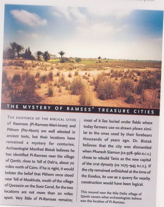
ผลที่สุดก็คือ Seti I เริ่มสร้าง กองทหารรักษาการณ์ ในเมืองใหม่ หลังจากปีนั้น เป็ฯที่รู้จัก Pi-Ramses-Meri-Imen (the house of Ramses the beloved of Amun) เมืองนี้ใน Bible เรียก Raamses พบจาก Piramses จากร่องรอย หิน กองพะเนิน ใกล้ๆๆ Qantir หมู่บ้านทางตอนเหนือ Faqus ห่างจาก Cairo 70 ไมล์ ทางตอนเหนือ
Source //www.worldwidewanderings.com/Dcp00813.jpg The Great Hypostyle Hall at Karnak begun by Ramses I (ca 1292 -1290 B.C.E.) was once supported by 134 giant columms
ในเวลานี้พูดถึง หนังสือ อพยพ Exodus King องค์ใหม่เกิดขึ้นในอียิปต์ พระองค์ไม่รู้จัก โยแซฟ เป็นไปได้ที่ King ในExodus กะคือ King Seti I " ดูจาก ชาวฮีบรูถูกกดขี่ อพยพ 1:8-9 8 กษัตริย์องค์ใหม่ขึ้นครองราชย์ในอียิปต์ พระองค์มิได้ทรงรู้จักโยแซฟ 9 ทรงประกาศแก่ประชาชนว่า "ดูซิ ชาวอิสราเอลมีจำนวนมาก และมี กำลังมากกว่าเรา Exodus Chapter 1:8-9
Then a new king, who knew nothing of Joseph 4 , came to power in Egypt. 9 He said to his subjects, "Look how numerous and powerful the Israelite people are growing, more so than we ourselves!
เชิงอรรถ 4 [8] Who knew nothing of Joseph: this king ignored the services that Joseph had rendered to Egypt.
Source:Institute for Biblical & Scientific Studies
Biblical ArcheologyBible and Archaeology, History, Discoveries Customs, Manners
THE BIBLICAL WORLD: AN ILLUSTRATED ATLAS National Geographic ISBN 9784 4262 01387 พระคัมภีร์พันธสัญญาใหม่คณะกรรมการคาทอลิกเพื่อพระคัมภีร์ NAB Bible and KJV Bible
Orchestra and four vocal Choir - *Latin* Recorded for the Anniversary of the Pope Benedict XVI April 19 This is the Anthem of the Vatican City. The Songs are called Inno e Marcia Pontificale ...


 ฝากข้อความหลังไมค์
 ผู้ติดตามบล็อก : 3 คน [

.jpg)


Chapter 1 11-12
11
Then God said, "Let the earth bring forth vegetation: every kind of plant that bears seed and every kind of fruit tree on earth that bears fruit with its seed in it." And so it happened:
12
the earth brought forth every kind of plant that bears seed and every kind of fruit tree on earth that bears fruit with its seed in it. God saw how good it was.
ปฐมกาล 1:11-12
11 พระเจ้าตรัสว่า "แผ่นดินจงผลิตหญ้าเขียว คือพืชที่มีเมล็ดและไม้ผลที่มีเมล็ดในผลแต่ละชนิดบนแผ่นดิน"
และก็เป็นเช่นนั้น
12 แผ่นดินผลิตหญ้าเขียว พืชที่มีเมล็ด และไม้ผลที่มีเมล็ดในผลแต่ละชนิด พระเจ้าทรงเห็ฯว่าดี
Source:ปัจจบรรพ คณะกรรมการคาทอลิกเพื่อพระคัมภีร์
Zagros Mountains, western Iran
Source://www.nationalgeographic.com/
wildworld/images/profiles/terrestrial/pa/lg/pa0446a_lg.jpg
Taurus Mountains of southwesten Turkey สูง6000ฟิต
Source://www.serhangungor.com/
album/serhan_gungor_taurus_mountains.jpg
ภาพถ่ายดาวเทียว ภูเขา Ararat Mountian ตุรกีสูง15,000ฟิต ผู้ที่เชื่อในพระคัมภีร์พันธสัญญาเก่า หลายศาสนาเยอะ เชื่อกันว่า เรือโนอาร์มาอยู่ที่นี้อะ
Source://www.worldwideflood.com
/flood/ararat/satellite.jpg
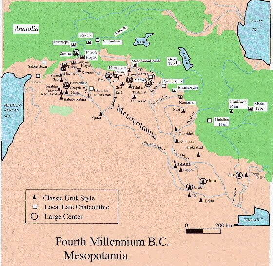
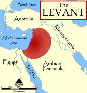
ดินแดน เมโสโปเตรเมีย Mesopotamia ภาษากรีก ความหมาย"The land" แผ่นดินอะ ดินแดนระหว่างแม่น้ำสองสาย แม่น้ำ ยูเฟรตีส Euphrates แม่น้ำไทกริส Tigris เป็นดินแดนที่มนุษยชาติเกิดอารยธรรม จากทะเลเมดิเตอร์เรเนียน ไปถึงทะเลทรายซีเรียน จนถึงทางตอนเหนือของอิสราเอล ที่เชื่อว่า คือ คานาอัน ในปฐมกาล
Source:รูปเอามาจาก //www.bible-history.com
ca 300,000 B.C.E
Eary evedience of modern humans
present near the sea of Galilee
ca 40,000 B.C.E
Stone tools in use
in ancient Israel
Source:
THE BIBLICAL WORLD: AN ILLUSTRATED ATLAS
National Geographic ISBN 9784 4262 01387
พระคัมภีร์พันธสัญญาใหม่คณะกรรมการคาทอลิกเพื่อพระคัมภีร์
NAB Bible