The geographical feature which dominates India most is the Himalaya. There are no mountain ranges anywhere in the world which have contributed so much to shape the life of a country as the Himalaya has in respect of India. It is not only the political life of the people of India, but also the religion, the mythology, art and literature of the Hindus that bear the imprint of the great mountain barrier.
To the Hindus the Himalaya have been a perpetual source of wonder and veneration; to the peoples of far south, east and west, the Himalaya have been the symbol of India. In a very special measure the Himalaya is India�s national mountain as the Ganga is its national river.
The Himalaya have contributed greatly to the soil formation and fertility, meteorology, social and economic life and isolation of India from the neighbouring countries.
The day of full moon, Purnima, in the month of Ashadh is traditionally celebrated as Guru Purnima by Hindus. Also known as Vyas Purnima, the day is celebrated in remembrance and veneration to sage Ved Vyas. He is the Adi (original Guru of the Hindu Dharma, who classified the Vedas, wrote the eighteen Puranas and the Mahabharat. On this day, the Guru is offered Pujan (worship) by the disciples. First we shall consider the role of a Guru in life.
It gives us divine pleasure in facilitating the pilgrimage of the all-faithful �Shiv-Bhakts� to the Mother of all �Tirtha Sthaan� - Kailash Manas Sarovar. Mount Kailash is one of the world�s most sacred spots. To experience its spiritual energy you must go there but with the right intention in mind. This is a pilgrimage and the intent should be to visit it for peace, both within each person and then the world. Tibetans leave an article of clothing or a drop of blood, hair or a stone to symbolize leaving their prejudices behind them. One should leave their ego, anxiety and meanness here.
Location: 3°04′ South Latitude, 37°21′ East longitude. Altitude: 5,895 metres (19,341 ft) First ascent: Hans Meyer 5th October, 1889
Kilimanjaro, with its three volcanic cones, Kibo, Mawenzi, and Shira, is the highest mountain in Africa at 5,895 metres or 19,341 ft above sea level. Its summit is the Uhuru Peak (or Kibo Peak). Mount Kilimanjaro is the highest freestanding mountain in the world, as well as the fourth most prominent, rising 5,882 metres or 19,298 ft from the base. Its local names are Kilima Njaro in Swahili and Oldoinyo Oibor in the Masai language; at the highest elevations the climber finds a zone of permanent ice and snow which is responsible for the name Kilimanjaro, �the mountain that glitters�.
There are six routes by which to climb Mt Kilimanjaro. The climb is technically easy, but the combination of altitude, low temperature and occasional high winds make this a difficult and dangerous trek. Acclimatisation is essential due to altitude sickness, cerebral and pulmonary edema. Park estimates indicate that only 40% of climbers actually reach the Uhuru summit, with the majority turning around at Gilman�s Point, just 300 metres short of Uhuru. The very arduous Western Breach scrambling route is highly susceptible to avalanche on the mountain. The Western Breach route was closed in January 2006 when 3 Americans and 5 or 6 guide/porters were killed in a rockslide. Typically, 8 or 9 climbers per year die on the mountain.
2.Mount Kosciuszko
Location: Latitude 36° 27′ South; Longitude 148° 16′ East Elevation: 2,228 metres (7,310 ft) First Ascent: Count Pawel Edmund Strzelecki, 1840.
Mount Kosciuszko is located in the Snowy Mountains in Australia�s Kosciuszko National Park. With a height of 2,228 metres (7,310 ft) above sea level, it is the highest mountain in Australia (not including its external territories). It was named by the Polish explorer Count Paul Edmund Strzelecki in 1840 to commemorate a Polish national hero, General Tadeusz Kościuszko. Interestingly, measurements of the peak showed it to be lower than its neighbour, Mount Townsend, so the names were exchanged in order to preserve Kosciuszko as the name of the highest peak.
As with many of Australia�s highest peaks, Mount Kosciuszko is not especially difficult to climb. From Charlotte Pass it is an 8-kilometre (5 miles) trek up a path to the summit and from Thredbo 6.5 kilometres (4 miles).
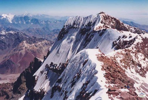
3.Mount Aconcagua
Cr.Agentina discovery
Location: 32° 39′ S Latitude, 70° 14′ W longitude. Altitude: 6,962 m (22,841 ft) First ascent: Mathias Zurbriggen, 1897
Mount Aconcagua, known as the �stone sentinel�, is the highest mountain in the Americas at 6,962 m (22,841 ft), and the world�s highest mountain outside Asia, located in the Andes, in the Argentine province of Mendoza and about 15km from the Chilean border. Mount Aconcagua has the honour of being the highest peak in both the Western and Southern Hemispheres. The challenge posed by Mount Aconcagua is often underestimated by climbers, which has resulted in serious injuries and deaths.
The mountain is part of the Aconcagua Provincial Park and its local name is Cerro Aconcagua. It has a number of glaciers, of which the largest is the Ventisquero Horcones Inferior (about 10 km long) and there are two other large glacier systems: the Ventisquero de las Vacas Sur and Glaciar Este/Ventisquero Relinchos system at about 5 km long. The best known is the north-eastern or Polish Glacier, which is a common route of ascent to the summit for climbers. The effects of altitude can be severe (atmospheric pressure is 40% of sea-level at the summit), but supplemental oxygen is not required in climbing it. The mountain often has brutal weather with cruel winds, driving snow and severe white-out conditions creating a nightmare experience for climbers � five died on the mountain in 2009. The rate for successful ascents is only 30%.
4.Mount Elbrus
Location: Longitude 43°21�18″North Latitude 42°26�21″East Altitude: 5,642 metres (18,510 ft) First Ascent: A. W. Moore, F. Gardiner, F. Cruford Grove, Horace Walker, Peter Knubel in 1874
Mount Elbrus is an inactive volcano in the western Caucasus mountain range in Russia, near the border with Georgia. Mt. Elbrus�s highest peak is the highest mountain in the Caucasus, in Russia and also in all of Europe. Mt. Elbrus�s west summit rises to 5,642 metres (18,510 ft); the east summit is lower at 5,621 metres (18,442 ft). The local (Balkar) name, Mingi-Tau, means �resembling a thousand mountains�, because Elbrus is such a large mountain. The mountain�s permanent icecap feeds twenty-two glaciers, which in turn feed the Baksan, Kuban, and Malka Rivers. Mount Elbrus was last volcanically active in the 1st century AD.
Challenging ascent routes have been identified, for example arriving from the east up the Iryk valley, along the Irykchat glacier and over the Irykchat pass (3667m) on to snowfields below the ribs of the eastern spur. By number of deaths, Elbrus is one of the world�s most lethal mountains: the average annual death toll on Elbrus is 15-30 climbers, but forty-eight climbers, skiers and snowboarders died in the Mount Elbrus area in the year 2004. Sudden storms and extremely cold weather are very common in this region, and there are many frostbite and hypothermia injuries and deaths on the mountain every year. Due to political unrest and the threat from Chechen extremists, the UK Foreign and Commonwealth Office have advised against travel to the Elbrus region for the past eight years.
5.Mount Denali
Location: Latitude 63° 07′ N, Longitude 151° 01′ W. Altitude: 6,194 m (20,320 feet) First Ascent: Hudson Stuck, Harry Karstens, Walter Harper and Robert Tatum on 7th June, 1913
Mount McKinley or Denali in Alaska, USA, is the highest mountain peak in North America at 20,320 feet (6,194 m) above sea level, located in Denali National Park and Preserve. Denali, meaning �The High One�, is the Native American (Athabascan) name for the peak. The mountain is a granitic pluton, uplifted by tectonic pressure, from which erosion has stripped away the sedimentary rock around the mountain. It has two peaks: the South Summit is higher while the North Summit has an elevation of 19,470 feet (5,934 m) and a prominence of approximately 1,320 feet (402 m). Five glaciers flow from the mountain�s icecap. Although Mount McKinley has a larger bulk and rise than Mount Everest, Everest�s summit is higher at 29,029 feet (8,848 m). Everest�s base sits on the Tibetan Plateau at about 17,000 feet (5,200 m), giving it a real vertical rise of little more than 12,000 feet (3,700 m). The base of Mount McKinley is roughly at 2,000-foot (610 m) elevation, giving it an actual rise of 18,000 feet (5,500 m).
Dealing with the commitment, physical endurance, altitude and Arctic cold and storms, provides an incredible challenge to climbers. Mount MView Larger MacKinley is noted for its extremely cold weather, with temperatures as low as −75.5 °F (−59.7 °C) and windchills of −118.1 °F (−83.4 °C) recorded by an automated weather station at 18,700 feet (5,700 m). The coldest weather on Denali is experienced from November to April, with average temperatures ranging from -30F to -70F. The weather conditions alone make Denali a severely challenging climb. It is usually considered the tenth most dangerous mountain for climbers, and the �coldest� mountain in the world. On average, only 40-50% of climbers who set out on the ascent actually reach the summit, and over 100 have died on the mountain. 2010 saw at least two more fatalities.
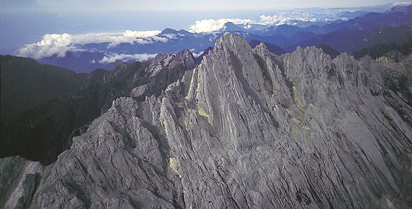
6.Carstenz Pyramid
CR. American Alpine instutute
Location: Latitude 4.08°South, Longitude 137.18°East Altitude: 4,884 metres (16,024 ft) First Ascent: Harrer, Temple, Kippax and Huizenga in 1962
The Carstensz Pyramid (also called Puncak Jaya, or Mount Carstensz) is in the Sudirman Range in the western central highlands of Papua province, Indonesia. Rising to 4,884 metres (16,024 ft) above sea level, it is the highest mountain in Indonesia, on the island of New Guinea, and in Oceania. Its peak is the highest point between the Himalayas and the Andes, and the highest island peak in the world. The mountain was closed to tourists and climbers between 1995 and 2005, but from 2006, access has been possible. The �Free Papua� separatist political movement has been struggling for independence for over 30 years, sometimes with lethal consequences for climbers in the region.
The Carstensz Pyramid is one of the more demanding climbs in the Seven Summits challenge, although it does not feature in the Bass List. It is considered to have a higher technical rating than any of that list�s summits.The standard route of ascent is up the north face and along the summit ridge, which is all hard rock surface. The surrounding area is inaccessible necessitating a 100-km hike from the nearest airport at the town of Timika to base camp. The mountain is hidden in dense jungle and the climber must be prepared to climb in snow and rain, with his gloves being torn by the sharp rock. In order to cross the largest gap on the summit ridge, the climber must ascend a horizontal line of about 20m by hanging under a rope at 4800 m and pull himself through to the other side. Its geographical remoteness, combined with government restrictions, political instability in the region and frequent tribal warring, has meant that few people have climbed it since the first ascent.
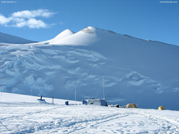
7.Mount Vinson
Cr.Seven Summits
Location: Latitude 78°35′South, Longitude 85°25′West Altitude: 4,892 metres (16,050 ft) First Ascent: expedition led by Nicholas B. Clinch, 11.30am on 18th December 1966
The Vinson Massif is the highest mountain in Antarctica, about 1,200 km (750 mi) from the South Pole. The massif is about 21 km (13 miles) long and 13 km (8 miles) wide. The highest point is Mount Vinson, reaching 4,892 metres (16,050 ft) while the southern end of the massif ends at Hammer Col, joining it to the Craddock Massif, of which the highest point is Mount Rutford (4477 m). The mountain is considered the 7th most dangerous mountain climb in the world its isolation, combined with the extreme cold and unpredictable weather on the Antarctic continent, makes climbing Mount Vinson a very serious undertaking.
The climate on Mount Vinson is regulated by the polar ice cap�s high-pressure system creating mainly stable conditions, along with the possibility of high winds and snowfall. Although annual snowfall on Vinson is low, high winds can cause base-camp accumulations up to 46 centimetres (18 in) in a year. During the summer season, November to January, 24 hours of sunlight per day may be experienced and, although the average temperature is then −30 °C (−20 °F), the intense sun will melt snow on dark objects. Even a small accident here could be disastrous. Antarctica is the world�s last great wilderness and remains virtually completely undeveloped and unpopulated, due to the hostility of its climate. It is a land of extremes which epitomises the concepts of remoteness, harshness and isolation. In recent years, expeditions have enjoyed a good success rate and over 200 climbers have now climbed the mountain.
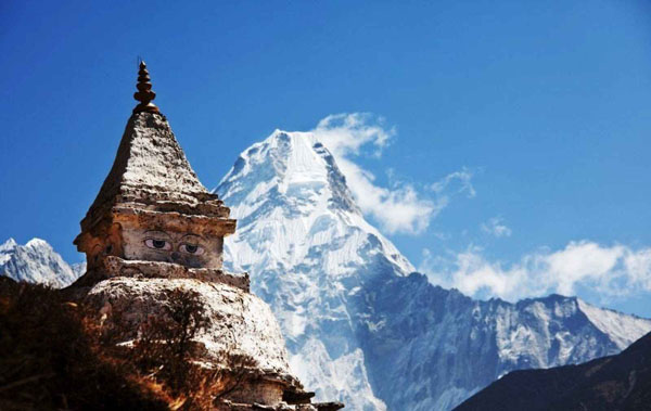
8.Mount Everest
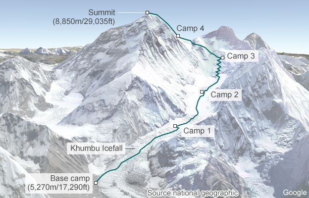
Location: Latitude 27° 59′ North Longitude 86° 56′ East Altitude: 8,848 metres (29,029 ft) First Ascent: Edmund Hillary and Tenzing Norgay, 1953
Mount Everest (also known as Mount Chomolungma and Sagarmatha �goddess of the sky�), is the world�s highest mountain at 8,848 metres (29,029 ft), situated in the Himalayas on the Nepal � China border. Its pre-eminence was established when, in 1856, the British Great Trigonometric Survey ascertained the first published height of Everest, then known as Peak XV, at 29,002 ft (8,840 m). In 1865, the mountain was given its official English name by the Royal Geographical Society, in honour of Sir George Everest.
Everest attracts many experienced mountaineers as well as climbers who pay professional mountain guides to complete the ascent. The mountain has many inherent dangers including altitude sickness, weather and wind. By the end of 2010 Everest had claimed 220 lives, and conditions are so difficult in the �death zone� (higher than 8,000 m/26,246 ft) that most corpses have been left where they fell. Some are still visible from standard climbing routes, and Everest is considered the 9th most dangerous mountain for climbers. Exhaustion, the extreme cold, the dangers of the demanding climb and the low level oxygen (pressure is about one third of pressure at sea level), makes Mount Everest a very challenging climbing objective. Over the years, 1 in every 10 successful climbs has ended in death, as the majority occur while descending the mountain rather than on the ascent to the summit. Above 8,000 meters the terrian is called the �death zone� due to the low oxygen levels, so most climbers use supplementary oxygen once past this point.
Mount Everest has two main climbing routes, the southeast ridge from Nepal and the northeast ridge from Tibet, as well as many other less frequently climbed routes. Of the two main routes, the southeast ridge is technically easier and is the more frequently used route � this was the route used by Edmund Hillary and Tenzing Norgay in 1953 and the first recognized of fifteen routes to the top by 1996.
Create Date : 30 �Զع�¹ 2551 Last Update : 17 �ԧ�Ҥ� 2560 10:44:38 �. Counter : 2967 Pageviews.


 �ѹ���: 3 �á�Ҥ� 2551 ����:3:57:27 �.


 ���Դ������͡ : 2 �� [